Drone surveys in your community
We appreciate that you may have questions about how and why we are using drones to survey your community. This page carries information on why and how we are using drones, and what we do with the imagery once we have it.
We have taken every precaution to protect your privacy, and to be transparent in how we are using drones to complete surveys. Please note that we do capture any personal data in these surveys (for more information on this please see the section on privacy below).
All drone operations are carried out by certified operators in full compliance with the UK Civil Aviation Authority (CAA) regulations, including the General Visual Line of Sight Certificate (GVC), and with appropriate insurance coverage.
We have followed the guidance from the Information Commissioner Office (ICO) on the use of drones by:
• Using an operator who is registered to fly them by the Civil Aviation Authority (CAA)
• Placing clear, Wessex Internet branded signage, next to the operator whilst they have been undertaking drone surveys.
• Emailing those in the community where we have their email addresses notifying them that we will be undertaking drone surveys of where they live.
• And providing a printed flyer outlining why we are undertaking drone surveys and what we intend to do with the information we have collected. If you have further questions, please do not hesitate to contact us here: community@wessexinternet.com.
Drones offer a quick and efficient method of surveying
The use of drones equips us with highly detailed imagery of the ground conditions in communities we are building to. By mainly using them for our rural builds, we are reducing the amount of personal information we might be collecting.
Compared to traditional survey methods, drones offer a unique set of advantages both for the community we are building to but also to the way we build our network:
• We can survey a large area without causing disruption to a community. Compared to using teams of surveyors on foot, the imagery from a single drone can capture key details that can be analysed in the office to pinpoint where additional in-person survey activity might be required.
• Drones capture clear, high resolution imagery versus satellite imagery. The detail in drone imagery helps to highlight where we need to bring our network into a community, plan how to connect specific properties to the wider network and to help us accurately plan the amount of materials we need to complete a build.
• We can plan the best routes to build our network into a community. The level of information captured by drone cameras means we can plan out routes for our network that create the minimal amount of disruption to a community. For example, this could be by identifying a route that avoids the need to close a road, to identifying the best way to take fibre optic cable across a piece of land.
Of all the benefits drone surveys offer, the main benefit is that by using them it helps speed up our surveying process and ultimately means we can connect communities faster.
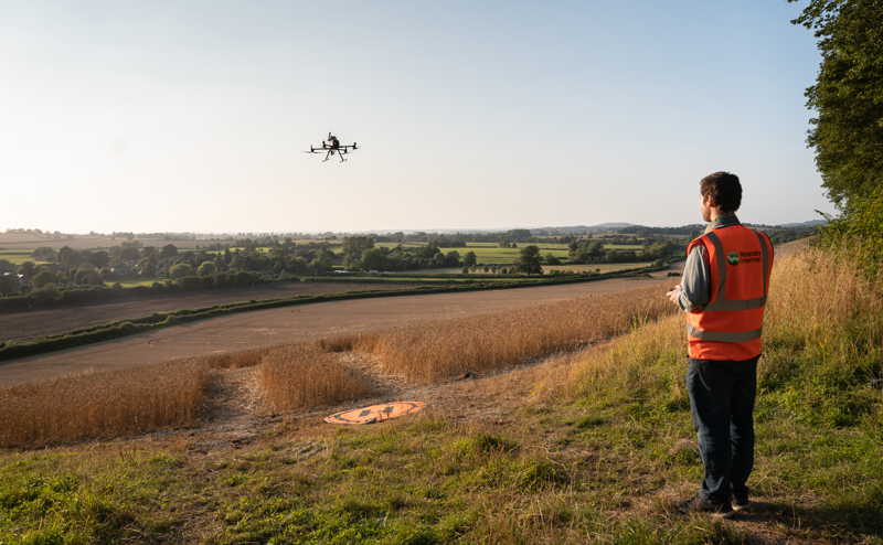
Our drone operator is fully compliant and insured.
Our drone operator is registered with the CAA and is a qualified and experienced operator, who is mindful of the local environment.
The drone they are using is ultra lightweight (under 250g in weight), and once airborne our operator will always keep a direct line of sight with the drone. The drone also uses GPS to help avoid any obstacles that might be encountered.
Protecting your Privacy
Filming will only commence once the drone is at 50 metres* in height with all imagery sent back and recorded by the operator. Once a specific community has been surveyed the data will be shared by the operator via a password protected FTP website.
*Exceptions to this would be (i) where we are surveying telegraph poles at around 10-15 metres and (ii) from time to time way may agree alternative heights with homeowners/landowners when surveying their property. The drone imagery we capture will always be from a minimum height of 50 metres, with the drone camera pointing directly downwards. This means we won’t intentionally capture any personal data such as number plates, house names and numbers or people’s faces.
Any data collected during the survey is handled in accordance with UK GDPR and will only be used for the purposes of infrastructure planning and maintenance. No personal data will be retained or processed without legal basis
Once we have the imagery, it is only used by our planning team within a programme called QGIS. This can only be used whilst on Wessex Internet premises whilst connected to our network.
No other team in the business has, or would be able to, access the drone imagery we capture. We will hold these images for a limited time, because they are deleted once the build to that community has been completed. If you have any specific concerns regarding our use of drones and privacy, please contact: community@wessexinternet.com.
